Thursday, 21 April, 2022 , 17:01
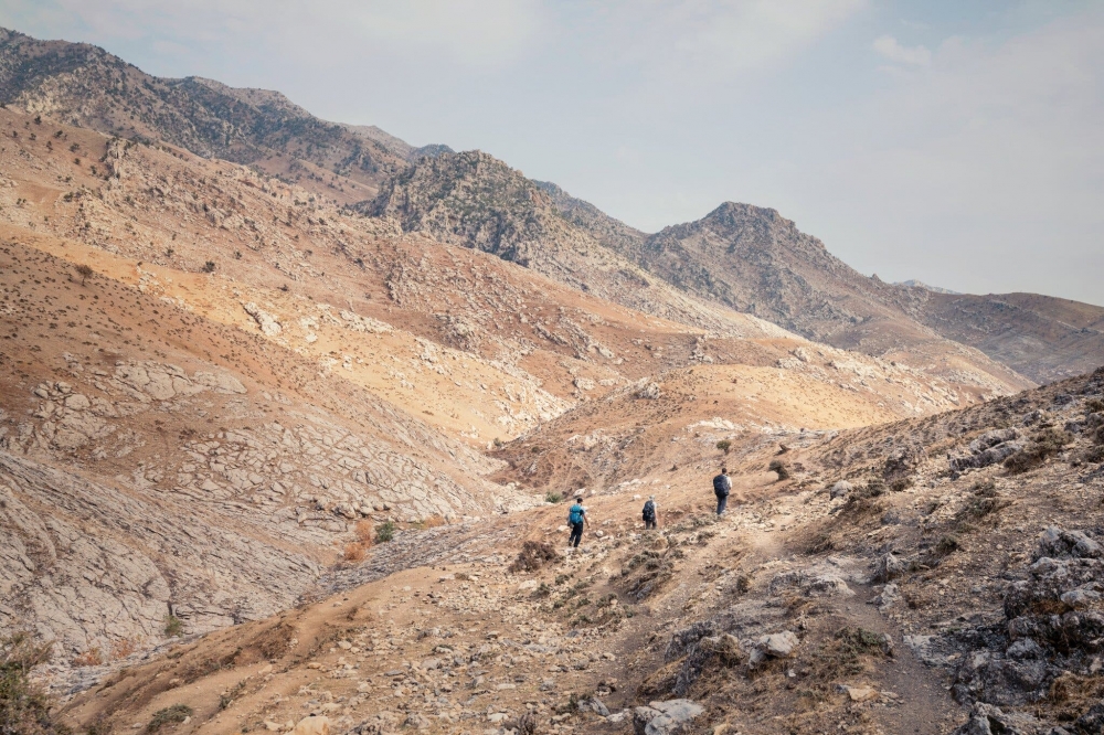
Hiking between Shush and Akre in the Zagros mountain range in Iraqi Kurdistan.
Credit...Andrea Frazzetta for The New York Times
Nytimes.com | Ben Mauk
Can it help knit together a nation?
Lawin Mohammad collects trails in the mountains of Kurdistan. He has met scores of shepherds on their daily wanderings. He confers with beekeepers on high passes. He follows aging pesh merga on their former patrols and waylays Christian and Yazidi pilgrims. When he is stopped on the highway at a military checkpoint, staring into the aviators of a heavily armed 20-year-old, he will ask the soldier whether he ever walks to the next village over. Or if his grandfather ever did. He makes inquiries among Syrians like himself who a decade ago took the dangerous crossing from Rojava into the foothills of the Zagros Mountains, in northern Iraq, at the start of the civil war. He parleys with children and imams. I have seen him work over at least one furtive treasure hunter. His informants are legion.
He does not know how many trails he has found in this way — probably hundreds. They do not always hold their shape for long. Trails braid and fray with daily use. Sometimes acts of nature — floods, drought, fire — close part of one path or open another; likewise acts of war, fences, I.E.D.s and tahini factories. In extreme terrain, trails may be augmented by raised berms, bridges and tunnels blasted from mountain depths, but such interventions are still rare in rural Kurdistan. Most walkers he meets in the Zagros follow the unpaved routes the mountains offer up to them, trusting in the collective genius of a thousand wanderers, no two of whom press exactly the same steps, but out of whose millions of foot-size contentions a mean is worn to smoothness. Through their collective walking, a path of maximal desire is formed.
Mohammad is a founding partner in a project to build a 150-mile-long hiking trail through the autonomous Kurdistan Region of Iraq, or K.R.I., from the Nineveh Plains to the snow-covered mountains that border Iran. The route approaches zones recently liberated from ISIS and borderlands where Turkey is fighting an asymmetric war against guerrilla fighters of the Kurdistan Workers’ Party, or P.K.K. Despite these complications, if all goes well, the tentatively named Zagros Mountain Trail will stitch into a single two-week-long route fragments of walks following old canals and seasonal grazing paths, passing Byzantine temples and Jewish shrines, all while navigating around some seven million unexploded land mines from the Iran-Iraq and Persian Gulf wars.
Until recently, it would not have been possible for a group of hikers to walk across Iraqi Kurdistan, a region that has experienced a continuum of violent political crises almost without interruption for a century. They include a Kurdish rebellion in 1943 put down by British warplanes; a revolution in 1961; revolts and government reprisals throughout the 1960s; air attacks in 1974 that displaced hundreds of thousands of Kurds; and a series of genocidal Iraqi military campaigns and mass killings from 1980 to 1991. The region then gained de facto autonomy through a bloody revolution but remained fractured and isolated until the 2000s. Its fate has lately shifted. The K.R.I. escaped much of the devastation that befell southern Iraq after the U.S. invasion and was finally recognized as a federal region in the country’s 2005 Constitution, inviting foreign investment and oil exploration.
‘You never really feel like you’re building trails out here. Only finding them.’
Once it is finished, the Zagros trail will be the first long-distance hiking route not only in Iraq but very likely in all of Kurdistan, a conceptual and unrealized country of mountains, pine forests, deserts and thousands of rural villages cleaved by colonial-era rulers into parts of modern-day Turkey, Syria, Iraq and Iran. There are models for such marathon enterprises — the Appalachian Trail, the Camino de Santiago, the Pennine Way — which attract hundreds of thousands of hikers annually and have transformed the economies of rural regions through which they pass. But none have yet been attempted in the Middle East’s canonical shatter zone.
One afternoon last November, Mohammad and his partner in this quixotic venture, an Irish explorer named Leon McCarron, led a small group over a mountain pass above Akre, a Kurdish city where people have been living without interruption since the Iron Age. The pass is punctuated every Nowruz by hundreds of flaming torches, but it was now empty. At the highest point of the pass sits a temple fortress carved out of the limestone mountaintop. Akreans call it the citadel. Every structure in the citadel is rock. The sunken great hall is carved from rock; the prison, with its despair-inducing ventilation holes, is rock; the conical, gypsum-lined wells are rock. In the first millennium B.C., its anonymous builders cut windows into two-foot walls of rock so that sunlight would reflect off the prismatic surfaces and illuminate rooms of rock with diffuse afternoon light. This detail, which I passed over blindly, captured Mohammad’s imagination when he first encountered it. “It’s my favorite part of the trail,” he said. “Who were these people here? Were they the ancestors of the Kurds? Were they my ancestors?”
On the far side of the citadel, a mysterious trench bisects a field of bedrock. It is thought that water was once carried through this sluice in terra-cotta pipes. Today it permits hikers to walk across a bowl-shaped expanse of limestone from beneath the surface of the earth, entombing themselves in mountain. The trench is almost perfectly straight and in places so narrow you have to turn sideways to move forward. As we crossed it, Mohammad told me his philosophy of trail-finding.
“I’ve hiked this mountain pass three times,” he said. “I hike this route and that route, and if I feel pain in my muscles, it’s not right. Sometimes I can feel it in my teeth.” Other trail designers sometimes talk about a route’s flow or story. A good trail breathes in and out, up and down. High climbs end in restful vistas. Meditative footpaths open onto wide, convivial clearings. “It comes down to a question of why the route is here,” Mohammad said. “Why here? Why this way? Your muscles can tell why a trail exists. Maybe it’s a road for pesh merga who were hiding from the military, and so it’s difficult by design. Or maybe it’s the shortest path between two villages.”
Or maybe, he added, “a donkey made it.” Not only men and women but cows, goats, sheep and asses contribute to the great anonymous masterpiece of a walking trail. In Kurdistan, you can often determine a path’s strenuousness by the kinds of dung found along it. A path blooming with cow patties is likely to be less grueling than one marked only by the dark, nutlike excrements of goats, who can get up anywhere.
Above us rose a barren yellow slope in radiant sunlight. Behind us was McCarron — tall, angular, stubbled — who was similarly voluble on the subject of trails. The dung trick came from him. “A trail only exists because people value it,” he said as the citadel fell out of view. “We’re not ‘building’ any trails that don’t already exist. Nobody owns it; no one person builds it.”
“You never really feel like you’re building trails out here,” Mohammad added. “Only like you’re finding them.”
Some people are drawn to the landscapes of their homelands; others are driven to escape them. McCarron was born on a farm in Northern Ireland. The farm is near a seaside town called Castlerock that is damp to its basalt with the smell of the Atlantic. C.S. Lewis holidayed in Castlerock as a child and is said to have put its ruined cliff-top castle into Narnia as Cair Paravel, “with rocks and little pools of salt water, and seaweed, and the smell of the sea and long miles of bluish-green waves breaking for ever and ever on the beach.” When he left home for college, McCarron chose the most foreign place his mind could envision, which at the time was Canterbury, England. “It didn’t occur to me I could actually leave the British Isles,” he said. Since then, he figures he has traveled around 30,000 miles under his own steam — by foot, by bicycle, by oil-drum kelek. He has crossed Patagonia on horseback and walked from Mongolia to Hong Kong. In addition to Lawin Mohammad, his partners have included the North Face, Red Bull and the Royal Geographical Society, where he is a fellow in good standing.
McCarron dates his interest in trail building to 2015, when he was traveling among Israelite Samaritans in the West Bank. An American nonprofit called the Abraham Path Initiative was funding the construction of a new trail based on old trading routes and pilgrimage sites, following the legendary travels of the common patriarch. McCarron walked it, together with other trails in Israel, Egypt and Jordan. “I ended up writing a book,” he said — a travelogue called “The Land Beyond” — “and trails became a much bigger part of my life.” He spent a month apprenticed to a friend working on the Armenian branch of the Transcaucasian Trail, then teamed up with a trail designer named David Landis to build a long-distance hiking route in Hunan, China.
He came to Iraq for the first time in 2016 with more journalistic ambitions. As his plane landed in Erbil, he saw fighter jets scrambling on the tarmac below. It was the first day of the battle of Mosul. When he got to the front lines, his fixer warned him about I.E.D. trip wires hidden in teddy bears. “Not my beat at all,” McCarron decided. A mutual friend suggested he talk to Mohammad before his flight home. They met at a cafe called Everest.
Although Mohammad understood the Zagros as part of the homeland that all Kurds share, he had never gone hiking and was still new to the area himself. He arrived in Erbil in 2012, finding work as a hotel concierge. Meeting McCarron intrigued him, he said. “You know how they say some souls are close?” McCarron felt the same way. He decided to return to Iraq a few weeks later. They went to the mountains. “It blew my mind,” McCarron said. “It was the most beautiful country.” The following year they worked together on a documentary film about the Zagros, “Among Mountains.” The explorer was ignorant of tribal politics, land mines and P.K.K. hide-outs. “He didn’t know,” Mohammad told me, giggling mischievously. “I had to teach him!”
Everywhere they went, they asked the same question: “Where does this trail go?” In this manner, the pair began to map, possibly for the first time in the region’s written history, the immense and constellated firmament of trodden ways by which humans and animals have marked the Zagros Mountains. It is a network with no tribal or national distinctions, one far older than the Treaty of Sèvres or the Sykes-Picot Agreement. As they walked, the pair began to develop the idea for the Zagros trail.
They are odd yokemates. Unlike McCarron, whom I could easily picture arms akimbo on some icy summit, Mohammad does not much resemble a mountaineer. His cherubic face defaults to a broad smile, and his voice, instantly recognizable from across a canyon or a crowded restaurant, is oversize and jolly, a jeroboam at a dinner party. In Damascus, before the war, he was a literature student who preferred Marlowe to Shakespeare and Dostoyevsky to all others. On his first hike with McCarron, walking a donkey trail in the middle of winter, he wore jeans and motorcycle gloves, and while crossing the trench beyond the citadel, he joked to me that the passage was his diet program; his goal was to get down to a weight that would allow him to fit through without sucking in his stomach.
For Mohammad, hiking a trail is an excuse for meeting new people. For McCarron, the opposite is also true. They have developed a division of labor that plays to these strengths. McCarron gathers huge data sets — geographic, political, meteorological — while Mohammad practices rural diplomacy. “Leon writes down everything, he does all the GPS stuff,” he said. “But the network of people we’ve built, I keep that in my head.”
Like other trail makers I’ve met, they are improvisers. There is no international trail-building guild, no global standards to adhere to. How could there be? “It’s like asking, ‘How long should a piece of string be?’” Galeo Saintz, the international chair of the World Trails Network, told me. “It depends what it’s for.” Some organizations, including Saintz’s, are working to codify general principles of trail stewardship and an accreditation program to which trail organizations can apply, but these efforts are provisional, a response to the explosive growth of ecotourism projects worldwide. “We recognized it was essential for trails to learn from each other, to connect,” Saintz said. “Trails were stuck in their own silos.”
Some national trail networks are developed by government agencies and tourist boards, but these authorities often miss the journey for their destinations, designing trails around landmarks and cash-cow resorts; because the paths have little to do with vernacular walking habits, they quickly wither away. Some of the most esteemed long-distance trails in recent years have been built by willful enthusiasts. The 264-mile Jeju Olle Trail in South Korea began as the vision of a former journalist named Suh Myung Sook, who was inspired by walking the Camino de Santiago. Saintz considers it one of the most successful trails in the world, with nearly 800,000 visitors each year, most of them Korean. “She ignited a passion for hiking and walking within the local community, and that has been in my view the reason for its long-term success,” he said.
In developing a trail that is attractive to local and international walkers alike, McCarron has studied guidelines published by the U.S. National Park Service, recommendations of the World Trails Network and the in vivo standards of neighboring trail systems. The Jordan Trail, which debuted in 2016, is an especially important model. The 419-mile route was privately designed by a mixture of local and foreign hikers and is maintained by a locally run NGO, the Jordan Trail Association. The association helps preserve and promote the trail and provides hikers with maps, guidebooks and official permission to enter restricted areas in the form of a trail passport. It also connects hikers with hosts, guides and tour agencies along the 75 villages through which the trail passes.
Mohammad is laying the groundwork for a similar organization in Iraqi Kurdistan, one he is likely to head. He hobnobs with members of the tourism ministry and the hiking federation and checks in with a state intelligence agent, who advises him when an airstrike may be imminent. Some of these bureaucrats might be surprised to learn that for years they were dealing with an undocumented asylum seeker. When he arrived in Iraq, Mohammad was “not even a refugee,” as he puts it. He never registered with the United Nations High Commissioner for Refugees because he refused to forfeit his Syrian ID card, the only form of identification he’d ever had. Plenty of Kurdish families did not even have that where he came from, a village on a wedge of Syria where you could see hilltops belonging to Iraq and Turkey from the nearest highway. It was the first landscape he came to know by the length of a step. As a child, he used to walk three miles to school on a mud path that became impassable in winter. When the war came, he crossed a smuggler’s bridge into Iraq at dusk and spent the next night in a mountain clearing. He woke up with pebbles in his pockets.
Joining Mohammad and McCarron on the hike above Akre were two other habitual walkers. One was Emily Garthwaite, a photographer who is McCarron’s partner and lives with him in Erbil. She has been documenting their trail work since 2019. The other was a former rare-bird poacher from Akre named Sadiq Zebari, an old acquaintance whom the team members were auditioning as a trail guide, partly to steer him away from his less savory profession. Zebari hunted the kaw, or chukar partridge, a game bird with zebra flanks that is an unofficial national bird of Kurdistan, prized for its song and meat. It was an addiction, Zebari said, and the great passion of his life. “I hunted them since 2003 and quit in 2019,” he said unhappily as we rested by a stone wall. “Imagine smoking for 16 years and then quitting.”
“He would know,” Garthwaite said. As we walked, Zebari chain-smoked Milano cigarettes, empty packs of which littered the path ahead of us. Zebari was up in the mountains most days. Instead of birds, he now collected firewood to sell in the Akre bazaar. He was wearing wool pants, an old cable-knit sweater and counterfeit Louis Vuitton sneakers. The mountains were his home. He strolled up steep inclines as if he were walking a quay, hands behind his back, taking leisurely steps that nevertheless left him, through some sleight-of-foot magic, far ahead of everyone else. We passed a pomegranate grove, one rendered famous by a Kurdish song Mohammad began to sing in which its fruits were compared to a lover’s breasts. A man on horseback rode by on a roadcut in the bluff above us, a rifle strapped to his shoulder. He nodded as he passed. It was Zebari’s cousin.
In 2019, after years of day hikes and weekend overnights, the Abraham Path Initiative began funding Mohammad and McCarron’s efforts and providing strategic guidance, what they call “nurturing” a trail project, as they have several others in Southwest Asia. A.P.I.’s executives told me they view the Zagros project as aligned with their own mission to bring together at walking speed peoples and cultures from across the wanderings of the founder of three major monotheisms. (They also emphasized that the trail has no official name, and will be named — and run — by an Iraqi Kurdish team. “The last thing this region needs is more outsiders coming in and telling them how to be,” Anisa Mehdi, A.P.I.’s executive director, told me.) That same year, Mohammad and McCarron scouted almost 125 miles of continuous trail. McCarron and Garthwaite moved to Erbil full time. Mohammad started building a Rolodex of family and tribal elders who wield influence along the imagined route. He sought out men and women with uncommonly reticulated mental maps of their home turf. Zebari was one of these.
A dirt military road led to a serrated ridge called Kale Mountain. Bearing east, we left the road and began crossing a wide drainage that sloped inward like a trowel. “Leon,” Mohammad called out. He pointed to a stand of oaks above us at the crest of the ridge. “See up there? Beside the rock outcropping? That’s our stretch point, where we rest, and then the trail descends. But we miss this spring if we take our usual trail.”
McCarron and Mohammad stopped to discuss the ridge, which like dozens of other mountain passes in Kurdistan they have hiked several times. There were always new things to see. We had wandered away from the established path to look at a natural spring fitted with a galvanized pipe and a stone cistern. Now we were east of the trail, meandering across a treeless declivity with no obvious route at our feet. The way above was more trail-like, with better views of the valley, but missed the spring, a potential water source for parched hikers. “I think I prefer to stick with the trail,” McCarron said. “That’s what we’ve been calling our official track.” He turned to face Mohammad. “Which do you prefer?”
“Yes, that one. It’s more balanced.”
McCarron marked the decision in Gaia, a GPS app he uses to record all their movements in the mountains. He made a duplicate mark in a pocket notebook and turned to me. “It’s part of our philosophy,” he said. “So long as you’re on a trail that’s marked by use, you don’t wonder whether you’re on the right path. But as soon as you’re on something like this” — he gestured to the pitted earth around us — “you start looking around and wondering, maybe feeling confused.”
Both routes are detours. The most natural path over the ridge follows the dirt road up to a former Iraqi Army base at Kale’s summit. “Saddam’s bases,” as such structures are still called, are found all over Kurdistan. The one above us was thought to be surrounded by land mines. By some measures, Iraq is the most mine-contaminated country in the world. When mountains thaw in the spring, they break loose and wash downhill with the snowmelt. “Oftentimes they have been mapped out by a demining organization,” McCarron said, “but just as often they haven’t, so you’ll have a situation like this.” The path toward the base was attractively well defined. It was probably the oldest herding route across the ridge. There were no warning signs. “And yet, as Sadiq will tell us, nobody ever goes there.”
To set McCarron’s Gaia maps next to the map of the 3,000 or so known minefields in the Kurdistan Region is a disturbing experience. Mines cover the highlands. The Iraqi and Iranian Armies placed them wherever combatants were likely to walk. Inasmuch as mines intend to interrupt and terrorize rural life in the Zagros, they remain successful long after Saddam Hussein’s withdrawal. “It’s hard to be nomadic around land mines,” Garthwaite said.
“Have any hikers run into a mine in recent memory?” I asked.
“No,” McCarron said, then grimaced. There have been occasional close calls over the years, some of which I heard about from Erbil-based tour operators. Halgurd, which is the highest mountain entirely within Iraq, lies at the prospective end of the Zagros trail and is a popular destination for climbers despite being heavily mined. Some tour groups were aware of the risks, McCarron said; others weren’t. There have been at least 13,400 mine victims in the Kurdistan Region since the early 1990s, including 42 in 2021, of which 19 were deaths. “All it would take would be one hiker to kill the future of tourism and all of the potential we’re building here,” McCarron said.
We were at least half a mile from the danger zone above Akre, but it was a good reminder that it would be a long time before visitors could hike the Zagros without a guide. According to Zebari, the last time a mine exploded on the ridge above us was in 1999. A cow set it off.
We sat in the shade of a crag near the top of the ridge. A shallow ledge was fitted with a faded sleeping bag and blanket — a shepherd’s hidden den. I wandered over to it. “No mines over here, right?” I called out.
“No,” McCarron said. “You’re fine.”
Our scouting that week began in Shush, a small village that is the project’s current trailhead. Shush is 244 miles north of Baghdad and 42 miles northeast of Mosul, the city that fell to ISIS in 2014 and was recaptured, thanks largely to the efforts of pesh merga fighters, in 2017. We set out from Erbil before dawn. As we approached the village, three men were waiting for us on a corniche, tapping their walking sticks into the mud. All three were members of the Akre Hiking Club. Two had fought to liberate Mosul; one was a pesh merga of 33 years’ standing. Pesh merga is Kurdish for “those who face death.”
Shush is a hillside of chockablock houses beneath a salt white limestone bluff. Walking into the village, we passed a plot of mossy gravestones so eroded by time that some could no longer be distinguished from the rocks around them. The cemetery belonged to Shush’s former Jewish community. Older townspeople retained a dim communal memory of the day in 1948 when the last family left for the newly established state of Israel. They had been living in an old stone synagogue below the village. It was an era of violent pogroms for Iraq’s Jews. Two of the hiking-club members were from Shush, and one was a history teacher. He gestured with a walking stick to each ancient ruin as we passed and lamented that the village once had many Jewish neighborhoods, some of which probably dated to the time of Yaqut al-Hamawi, a historian who describes Shush in his great Islamic geography. If you want a sense of the dizzying weight of history a person often feels in the Zagros Mountains, consider that al-Hamawi was born in 1179.
Shush’s mukhtar — the Levantine village equivalent of a mayor — was known to be perspicacious and wise, and he had brought a paved road and an electricity generator to the village, if not — yet — running water. He invited us to stay for breakfast and visit the rubblework monastery behind his house, which for many years he has used as a tool shed. We ducked under a timber lintel and stepped inside. In contrast to its Jewish community, no one in the village knew when the last Christian family left Shush. The building was used as a mosque until 1985, then abandoned. It was probably four centuries old, but there was no pomp of antiquity inside. In one corner was a pile of plastic fruit crates. A yellow rope strung across the ceiling held laundry on rainy days. There were propane lamps, air-conditioners and — propping up an old electric coil heater — a wooden munitions box that in stenciled German declared its contents to be two rocket-propelled grenades for an antitank Panzerfaust. A dog barked hungrily outside.
At breakfast, Mohammad explained to the mukhtar the idea of the Zagros Mountain Trail and invited him to become a stakeholder, lodging and feeding hikers who came through Shush. It was important not to overpromise at so early a stage, but at the same time to suggest what a trail could do for a village with no modern plumbing. Mohammad has spent years honing his pitch.
As he talked, McCarron quietly added the mukhtar’s monastery to the long list of ancient sites they have encountered on the trail, many of which have not received so much as a passing glance from an archaeologist in 50 years. Under the Baathist government, field archaeology was at best discouraged and at worst prohibited. Early studies of ancient Mesopotamia used declassified photos from the U.S. Corona spy-satellite program to map the canal system surrounding Nineveh, the heart of the Assyrian empire. The fall of the Islamic State has made a more intimate approach possible for the first time in half a century.
“Kurdistan is at the beginning of a new era,” Daniele Morandi Bonacossi, an Italian archaeologist, told me. Since 2012, Morandi Bonacossi has directed the Land of Ninevah Archaeological Project. “We have documented thousands of archaeological sites, well known to local villagers, but which only 10 years ago were totally unknown to the scientific community,” he said. “Authorities simply didn’t know they were there.” His most recent project, the excavation of a dozen Assyrian rock reliefs adjoining a canal at Faydah, was delayed for years, lying as it did fewer than 20 miles from the front lines against ISIS. In peacetime new threats have besieged Faydah, including cement factories and a farmer who raises cows nearly on top of a canal that predates the Roman aqueducts by four centuries. In 2017, in the process of expanding his cattle shed, Morandi Bonacossi said, the farmer managed to behead one of the monumental reliefs with a bulldozer.
It is the sort of threat a hiking trail might draw attention to, or so my guides hoped. According to Morandi Bonacossi, the areas where Mohammad and McCarron have been walking are dense with unstudied ruins and reliefs. Visitors arriving in Shush are sometimes stunned into reverent silence by the antiquity the village wears so casually, without effort or, it must be said, much attention to preservation, although that is changing. McCarron peered into the storeroom once more before we left the mukhtar’s house. “Well, it’s one step up from a cowshed,” he said. The first time they entered Shush’s ancient synagogue, a monumental dry-stone structure on the edge of a fig orchard, it was full of livestock.
The Zagros are the product of a violent collision. Around 20 million years ago, as the Arabian plate drove under the Eurasian, a belt of sedimentary rock lunged, as fast as rock can lunge, into the Miocene air. This uplift resulted in a row of harmonic northwest-to-southeast folds, like this — \ — between the Caspian Sea and the Persian Gulf, which on a contour map appear as a bolt of brown corduroy, one that has been wrinkled and whorled by giant fingers. Most of the range lies in Iran, but for a little less than a fifth of their length they are the most dramatic earthly feature of Iraqi Kurdistan. Large parts of the three Iraqi governorates that make up the K.R.I. sit atop the range’s high folds of limestone reefs, whose peaks and valleys are satisfyingly regular. As its designers envision it, the Zagros trail will send travelers perpendicular to these wales and ridges, day by day, valley to valley.
‘Trail builders are shock absorbers. We’re supposed to absorb the unexpected, the dangerous, the inconvenient.’
So variegated is every slope and surface in the Zagros that a good trail can hide right out in the open. From Shush we took a shepherd’s path along hillsides pitted with wells and hollows. It was a path that disclosed itself to McCarron and Mohammad only a few months ago, on their sixth or seventh visit to the area. Their former route drifted south beyond the synagogue along a raised jeep track, probably built for oil exploration. One day they passed a shepherd out with his flock, picking his way through what looked like a frictive field of boulders, but a mile later the shepherd reappeared ahead of them. The field had been a shortcut. The next time they came to Shush, they used it, too. The track followed sine-wave hills of limestone and shale strata with erosional grooves you could walk like a balance beam. It was quicker and more interesting than the jeep track.
“When you build a trail, you have to plan for it to be the same each time,” McCarron said as we entered a patch of thorny scrub. “Which route through a village, of three available, should you recommend that people take? Are you taking them up the side of a hill that might be sometimes blocked by sheep or goats? Are you accounting for small vehicles? Will the trail be flooded in the rainy season? Defining an exact route can take many trips.”
“Sometimes 10,” Mohammad added. “Sometimes you have to walk a trail 10 times before you know it.”
Garthwaite, who has walked nearly as much of the Zagros as McCarron and Mohammad, and whom I judged to be the strongest hiker present even with the added weight of her Leicas, told a story about returning to a familiar path on the eastern end of the trail, near Mawilyan, only to discover that, for obscure reasons, the bridge across the Rezan had been removed, forcing the party to backtrack several miles to hunt for a stretch of river shallow enough to ford. “The trails here are always changing,” she said. “Getting washed away, built over, snowed in, mudded, overgrown.”
“Trail builders are shock absorbers,” McCarron said. “We’re supposed to absorb the unexpected, the dangerous, the inconvenient.”
As we walked, a bluff rose up on our left, speckled with caves and blindingly white. We passed a stone trough for cattle and weathered man-made cutouts — wine press? old kiln? — in the shelf of rock at our feet. Garthwaite bent down to look for fossilized ammonites. The reef limestone complex around us was once underwater, she said.
It started to rain, a sudden downpour that was over as soon as everyone’s ponchos came out of their bags. We climbed a promontory that descended past a fallow plot of farmland and ended at Mar Odisho, a Nestorian monastery with stones that looked like fresh loaves of bread. We clambered through its austere, ruined chambers, which seemed mostly to serve prodigal cows, and onto the roof. The roof surrounded a central cloister in which a pomegranate tree had overgrown its yard.
Beneath Mar Odisho was a village named Gundik, where a string of flags advertised support for the Kurdistan Democratic Party, the larger of the region’s two major parties. Mohammad bought a lemon from the village grocer and squeezed the juice into his water bottle. A stone path winding through the village was full of diversion: ducks bathing in a stone canal; women stacking flatbreads into a tower; fast-boiling syrup in a metal pot. At the edge of the village, a beekeeper invited us to look at his apiary. Mohammad began his pitch. You never knew who might divulge knowledge of an untested route or secret cave.
We stopped again in the next village, Khirdas, so that the members of the Akre Hiking Club could visit the mosque. When we started again, one of the men, a longtime stakeholder in the Zagros project, described a path he knew that would take us off the jeep trail we had joined at Mar Odisho. Mohammad was intrigued. “Let’s try it,” McCarron said. The path proved difficult. We struggled along an uneven hillside of loose soil. Each step was a brief argument with gravity. McCarron noted that the friable clay we were walking on would fall apart underfoot in the dry summer months. “It’s not a trail, really,” he said. “It’s a scramble.” There were no cow pies. The summit, from which we would descend into Akre, seemed to recede even as we climbed toward it. A fact came involuntarily to mind, that the collision of the Eurasian and Arabian plates has never ended, and the Zagros are still rising out of the earth at the rate of an inch a year.
Tariq Kamil Aqrawi met us that evening wearing a dark navy suit that underscored our filth. A former Iraqi ambassador to Austria, he lived in Akre’s old town, into whose jewels we descended wearily, across Synagogue Bridge and into the empty bazaar. The previous week, Mohammad, through his tireless reconnaissance, identified the retired diplomat’s estate as a possible home stay. Now we were drinking tea in his trellised garden at sunset to the singing of bulbuls.
Aqrawi was pleased by the idea of a hiking trail. He loved Akre and had long worked to raise its status as an enduring Kurdish wonder. He was also delighted that I had flown from Germany, land of the beautiful German language. He asked me to translate stray words as he told us the story of his life: Boy Scout, grand opening, retiree. It was not easy to move back from Vienna, he said, a beautiful city to which he was posted after the fall of Saddam Hussein, and where his children still lived, but he wanted to retire close to the mountains of his youth and to build his Nostalgiehaus, a cultural center and museum of Akre life. This building, a renovated ruin across the alley from his house, was where we would spend the night. We carried our bags inside, and Aqrawi showed us rooms cluttered with history books and handicrafts. The house once belonged to Akre’s chief qazi, a 19th-century Islamic judge and scholar. Aqrawi had filled it with arcana from his own childhood: a Singer sewing machine, a silver tea tray and an old radio on which his father used to let him listen to transmissions from Tel Aviv and the BBC. After the Baaths came to power, it became the only way to get news critical of the regime.
We ate dinner at a family-style dolma restaurant where the food was sure to be fresh, the place having opened just the day before. As we ordered, the power went out. We drank tea by the light of cellphone flashlights and discussed the trail. Mohammad and McCarron wanted to know how the three local hikers had fared. One said he had never visited some of the towns we passed through despite growing up a few miles away. There was never a reason to. Another said he was amazed at how far we’d gone. Although Mohammad warned them ahead of time how many miles we would be walking, this was not the operative unit of measurement in the mountains. “We’ve never hiked five villages in a day before,” he said.
Outside the restaurant, electric lights strung from house to house bathed Akre’s main avenue in astringent pinks. The mountains and their caves loomed invisibly around us, black shapes against a black sky. Aqrawi appeared at my side. “That’s my old schoolhouse,” he said, pointing at a tall building across the road. “Ist es nicht schön?”
Two ridges and two days beyond Akre, near the village Barzan, we met a pair of young shepherds in a valley of old burled trees and sparkling waterfalls. The valley is famous for its role in the origins of the Kurdish insurgency in Iraq as well as for its connections to the conspicuously wealthy Barzani family, whose members include the president and prime minister of the K.R.I. The district has therefore escaped the deforestation and oil exploration that have marred landscapes elsewhere in northern Iraq. This valley was the greenest section of the trail, and we did not hurry toward our destination — Zorgavan, a river valley on the Great Zab — instead relaxing in a meadow while Mohammad quizzed the men on the routes they took each day. The shepherds were nonplused by the project but became serious about matters of geography. They patiently explained what they knew. Even though this leg was as finished as any part of the trail, I could see McCarron working out an espaliered network of alternate routes in his head.
Once McCarron and Mohammad were satisfied, Garthwaite hung back to photograph the shepherds, and McCarron and I found ourselves walking abreast. “What you just saw was the first two and a half years of trail building,” he said. “If you ask, ‘How do you get from Soran to Dargala,’ people are liable to say they don’t know. They say, ‘Nobody walks from Soran to Dargala anymore.’ ” But if you ask about herding routes, or about how older generations got from village to village, “then they will know, immediately, and show you.”
It fell to Mohammad to translate the act of hiking into more familiar activities, and to present as sites of leisure mountains that have long been bound up in Kurdish identity as zones of violence. They have served as refuge for guerrilla fighters and as the site of Hussein’s death camps and firing squads. The Baathist government killed as many as 180,000 Kurds in the Anfal campaign alone, a figure that does not include the crushed revolts of the 1960s, 1970s and early 1980s; those killed in wars with Iran, Kuwait or the United States; or those killed in wars and massacres elsewhere in greater Kurdistan — Syria, Turkey and Iran — where international hiking trails are not remotely possible. According to a shopworn saying of indeterminate age, “The Kurds have no friends but the mountains.” The saying is double-sided. It refers to acts of betrayal Kurdish communities have endured at the hands of supposed allies over the centuries — among them the United States government, which by one count has betrayed the Kurdish causes of nationalism and autonomy eight times — and to a history of hardscrabble survival in the Zagros, Taurus and Qandil ranges.
“We Kurds fled to the mountains, we hid in them, and in some cases pesh merga spent years living in them,” Mohammad said. “They really were our only friends.” We were crossing a field of dry Syrian thistle. Here a person might find the Kurdish alchemilla, the Syrian rhubarb and the Iranian onion sharing a single clearing. Now, Mohammad said, the mountains were for hiking. “Not hiding,” he said, relishing the wordplay. ‘‘Hiking.”
Because the trail to Zorgavan was nearly fixed, Garthwaite had invited two friends to join us for the day. The women were avid hikers. One of them, Meena Ayad Rawandozi, wore a blue windbreaker and a baseball cap over her long, straight hair. Her father was a government bomb-defuser who often hiked into Yazidi towns to neutralize ISIS ordnances. She wasn’t worried about mines; oaken nerves ran in the family. “He tells me, ‘Go to the mountains,’” she said. “He supports me.” Some years ago, Rawandozi joined a hiking club founded by a few university students. They chose a name — No Friends But the Mountains — anyone would recognize, and achieved viral fame on Instagram posting saturated photos of secret hiking spots. Soon, N.F.B.T.M. had thousands of followers. From five members they grew to 30, women and men, with Kurds, Assyrians, Turkmen and Arabs.
As the group expanded, Rawandozi began to think about the value of women’s access to the outdoors. She started climbing with an emergency rescue team to train herself to lead long-distance treks. “We don’t have a hiking group only for women in Kurdistan,” she said. “It’s a new thing for us.”
Recently, Garthwaite led a group of teenage female hikers on a walk in Music Valley, near Shaqlawa. The girls came from Sinjar and Mosul, and they had been living in I.D.P. camps for years. “They are not allowed to hike with men,” Garthwaite said. “We obviously need female guides.” Rawandozi seemed a likely candidate. In April, she took a group of Kurdish women on a daylong hike of her own design. She wanted the practice. This summer, she will lead an all-women’s expedition to summit Iraq’s highest peak.
I spent much of November following Mohammad, McCarron and Garthwaite across the length of the Zagros in northern Iraq, and sometimes beyond. One day Mohammad took me by car from Erbil to walk through a cluster of towns and ruins 50 miles west of the trailhead. Each place was crucial to the story of religious and ethnic cohabitation he wanted the Zagros trail to tell. They included a seventh-century Chaldean monastery, the Yazidi holy temple of Lalish and, at Khinnis, 2,700-year-old bas reliefs celebrating the canal system of King Sennacherib, who destroyed the city of Babylon and has a recurring role in the Old Testament.
Yet none of these sites were part of the trail, and they probably would not be for a long time. Besides land mines, the two greatest dangers to hikers in the Kurdistan Region are airstrikes and paramilitary groups. The trail legs Mohammad and McCarron have scouted in the Nineveh Plains, which include an early prospective starting point at the hilltop city Amedi, pass by regions where Turkey has executed hundreds of air- and artillery strikes targeting P.K.K. strongholds. Strikes have also occasionally landed east of Shush, near the prospective trail route, including an attack in Bradost in August 2020 that killed 15 people, five of whom were civilians. “There are so many beautiful mountains that we just can’t go to,” one tour operator in Erbil told me. As with land mines, a deadly strike on a hiking group could set the Zagros trail back a generation.
All hiking involves risks over which trail designers have little control, but Kurdistan seems particularly troubled by them. The region is facing historic droughts and water shortages. A resurgence by ISIS or a rise in other attacks — in March, Iran’s Islamic Revolutionary Guards Corps fired at least a dozen ballistic missiles into Erbil, seemingly in retaliation for an Israeli airstrike in Syria — could devastate an already enervated oil-based economy. The November of my visit, thousands of Iraqi Kurds were amassed on the border of Belarus and Poland seeking refuge in Europe. Reports of regionwide protests dominated the news when we were doing our trail work, with teachers, students and activists calling for democratic reforms, an end to government corruption and greater economic opportunity. Although the population is nearly united in favor of independence from Iraq, voters are increasingly disillusioned with the region’s two entrenched main political parties and their plutocrat leaders. Turnout for the 2018 parliamentary elections was the lowest in the Kurdistan Region’s history.
A trail will always be a work in progress, Aysar Batayneh, the chairman of the Jordan Trail Association, told me. There will always be bureaucratic hurdles, disputes with local landowners and safety concerns. “By looking at other trails, you see that the experiences and the pitfalls are often the same,” he said. On the other hand, no two trails are exactly alike, and secondhand knowledge goes only so far. “Every trail is a different puzzle to unlock,” Landis, McCarron’s co-designer in Hunan, said. “They are living organisms. You need to be connected to hikers who are there week to week.” Paradoxically, to help bring the Zagros trail into existence, the trail needed more walkers. Both authorities and local stakeholders needed to see its promise in the form of daily use.
Around the time of my visit, McCarron and Mohammad began to invite local hiking groups to join them on well-established sections of trail. One Friday, we revisited Shush with a young crew of weekend warriors from across the K.R.I.: backpackers, NGO employees, oil-industry workers.
As he walked, McCarron reflected on the work they’d done that month. “I feel good,” he said. A small boy from Khirdas was pushing a wheelbarrow alongside us. Inside the wheelbarrow were sticks. “Most of our progress this trip was what I’d call community outreach. But as you saw we also figured out a few connections, some just a few hundred meters long, and oftentimes those can be the trickiest to fix. You have to justify a whole day.”
Good trails are not cheap. A complicated day of trail work in Kurdistan might cost upward of $1,000, McCarron told me. The whole project is likely to cost hundreds of thousands, which still does not approach the high end. The Abraham Path Initiative developed the Palestinian Heritage Trail with a $3.3 million World Bank grant. Even well-funded trails must eventually become self-sustaining, although it is also true that investments in trails are often returned manyfold. The Jordan Trail Association claims its trail network has created more than 700 jobs since 2016 and generated $7.3 million in income, most of which stayed in local communities.
Three years after A.P.I. became a strategic partner, Mohammad and McCarron estimate the trail project is halfway to completion. They have invited other designers onto the trail, including Landis, who visited a month before I arrived to offer his expertise. Next month, they will face a vital test for any nascent trail: a through-hike. A group of seasoned hikers will walk the entire length of the trail, following local guides and sleeping and eating in guesthouses. Their feedback will influence the next round of trail revisions. Mohammad will also begin the process of registering an organization with the government under A.P.I.’s guidance. They will start training guides in wilderness first aid. Whatever its final form, the first through-hike is always a trail’s crux. “All of this so far has been behind the scenes,” McCarron said. “From this spring, we will launch the idea of the trail into the world.”
Once the idea’s shape is dependably fixed, meter by meter and path by path, the team will add blazes and way markings. From that point, Mohammad’s role will grow as McCarron’s diminishes. Someday, McCarron told me, he aims to work himself out of a job. Mohammad was bittersweet about this eventuality. “Leon has taught me so much,” he said. “At the same time, he knows that this trail is for local people. Leon will go to other experiences in his life. He will have another vision and go explore other places, and this Zagros trail will be for locals. For me or Jawwad or Anwar, or Sadiq, hundreds of people, like Tariq and Hama Soor ...”
Late in the afternoon outside Khirdas, a farmer was arranging pieces of shale to outline a grid of garden plots in the shadow of the ridge. One of the oil-company men, a Kurdish Canadian named Adam Mirani, was preparing to drive to Zorgavan that night to camp under the stars. “I would say five to 10 years ago, people seeing me camping were like, ‘What the hell?’” he said. “But it’s become a normal activity.”
“There’s been a lot of demining,” another hiker, Zerdasht Al-Haydari, said. “I wasn’t around when there were a lot of wars, but there were areas that were just dangerous.”
Flowering rosebushes lined the yard of Hama Soor’s house, one of the highest in Dargala. The village is tucked into the seam formed by two mountains, Handrin and Karokh, whose names are synonymous with Kurdish resistance. They are the sites of several battles between pesh merga and government forces, ranging from an early 1966 victory for Kurdish insurgents to clashes anticipating the 1991 revolution that granted the Kurdistan Region effective autonomy from the rest of Iraq. It is not unusual to meet Kurds named for such mountains. Mohammad’s youngest sister, born in Rojava the year of the K.R.I.’s founding, is named Handrin.
Hama Soor’s birth name was Ahmed Mustafa Hasan, but he was known everywhere in town by this appellation, Red Hama, which was his nom de guerre during the years he spent in the hills around Dargala as a pesh merga commander, and which referred to the everrose blush that spread out from either end of his mustache. The path to Hama Soor’s door was lined with firewood. “Where I’m from, when we see that much wood, we say someone has a lot of stress to work out,” McCarron said. “In Ahmed’s case, I think he’s just prepared.”
It was true that Hama Soor did not seem like a man often caught off guard. We showed up at his doorstep hours late at the end of a grueling 15-mile day. He had our bedding prepared and called his wife and children to bring tea and a dinner — lamb-stuffed wheat dumplings — that was, to my trail-weary palate, the most delicious food ever served in any country. For dessert, he poured a bag of speckled apples onto the carpet. The apples came from Karokh, where he had walked that day with his goats, and were as cold as creek water. Mohammad and McCarron could not resist asking about the trails he’d taken. Any trails in the area were Saddam’s, Hama Soor said, and poorly maintained. “The government doesn’t support us,” he said. “No one helps.” As we ate, he propped his phone against a bowl of sugar, and we watched the Undertaker fight Brock Lesnar and Big Show. Hama Soor’s 3-year-old son stumbled over, and Hama Soor melted into a puddle of kisses. Both father and son were beet pink. The Undertaker won.
We set out shortly after dawn for our final day of trail work. As we descended into Dargala, children were walking to school. It was a clear morning; from the right vantage, we could see into Turkey and Iran at the same time. A little closer were the mountains Mamarut and Omarava. Our destination was the saddle between them. Hama Soor wore the standard outfit of a Zagros goatherd: wide trousers, a broad waistband and a tasseled brown head scarf whose pattern was so typically Kurdish it sometimes got wearers in trouble in Turkey. He joked that I could have it on the condition I wasn’t flying home through Istanbul.
Hama Soor’s phone’s lock screen was a photo of himself as a young pesh merga: trim and serious, no less pink. His left hand did not close properly because there were two pieces of metal inside it. In 1987, while he was fighting Iraqi soldiers a few miles away in Mawilyan, a bullet struck his rifle, and fragments of the gun shot through his hand and lip. A year later, during the Anfal campaign, he took another bullet, this time in the right forearm. Without breaking stride, he pulled up his sleeve to show us the tidy entrance scar and the gnarly exit one. “It was chaos,” he said. “Everyone was fighting.” Iraqi soldiers dropped sarin and mustard gas on villages by plane in advance of infantry raids. It was the culmination of a decade of carnage. Within a year of the end of Anfal, a word that comes from a Quran sura referring to the “spoils” of holy war, 4,000 villages had been razed to the ground and two-thirds of Iraqi Kurdistan was emptied of Kurds. Dargala was destroyed and rebuilt several times over, he said, much as he was stitched up after each injury. He figured he had 20 pieces of metal in his body. When it snowed, they all hurt.
It was the first time McCarron and Mohammad had scouted this stretch of the trail with Hama Soor. Previously, the pair made mistakes. One trip took them in the shadow of a chicken factory. It smelled as only slaughtered chickens can. Hama Soor led the group along a path that skirted both the main road and the factory, following a fluvial terrace and entering, by way of a cemetery, a village at the base of the mountains. We reached a stone revetment along the river where four workmen were building a concrete bridge. “Really I like this way he showed us,” McCarron said. Mohammad agreed: “I’m really happy.”
Beyond the village, the group walked up Mamarut in high winds, stopping to rest in a screen of low, gnarled oaks. Garthwaite unscrewed her thermos and poured tea into rough-hewed wooden mugs. Hama Soor recalled the rustic provisions of his wartime hide-outs, filled with guns and radios captured from the Iraqi Army. He had been stationed in a place along the trail just ahead of us, called Seran. Garthwaite gasped. She had met families in Seran who suffered for years from the effects of chemical attacks.
Hama Soor said he had been lucky; he was gassed by Hussein just once. It was early spring, near the start of the first Anfal campaign. Something, a weapon, fell on Handrin. Within moments, everyone on the base smelled rotten apples. His lips went dry and cracked, and his eyes teared up. He ran with the others down to the nearest stream to flush the chemicals from his face. The day was windy and raining, and the wind blew the white smoke back toward the government line. Bad weather saved his life. In the valleys of the Zagros, where the gas settled, thousands were asphyxiated. Nearby, in Balisan, there was another attack where many died. At Seran, they held the mountain until the fall.
Of course it was completely different, walking now, Hama Soor said. Everything had changed. “Back then, we were in the mountains because we had no other options. We had nothing. We were poor. No one was there to help us. Now I see young people going to the mountains with purpose. Back then, we had nothing, and now they’re in the mountains by their own choice.”
The trail approached a truss bridge that crossed the Rezan River. Hidden behind a stand of poplars was a row of caves families had dug into the hillside as makeshift bomb shelters. Now they were storehouses. There was a question of how Hama Soor would get home — the rest of us were heading on to Choman, along the Iranian border — but even as it was being asked, he waved down a car whose driver he knew. McCarron paid him for our food and lodging, and for guiding us through the mountains. Garthwaite made a gift of the pair of wooden trail mugs. Hama Soor smiled and took them. “I’m sorry if anything was missing,” he said as we parted. “Sorry if it wasn’t perfect.”
“It was perfect,” Mohammad assured him.
Ben Mauk is a writer based in Berlin. His previous work for the magazine includes an article about a Cambodian floating village as well as an article about a trade hub on the border of China and Kazakhstan. Both stories were anthologized in “The Best American Travel Writing.”